

Quick answer
Iztaccíhuatl is a strenuous non-technical high-altitude climb, not a day walk: the La Joya trailhead sits above 3,900 m and the Pecho summit reaches 5,215 m. Fit hikers with acclimatisation manage it; altitude, loose volcanic scree and exposed ridgeline are the limiting factors. Access runs from Paso de Cortés, open 09:00–18:00 on weekdays and from 07:00 at weekends.
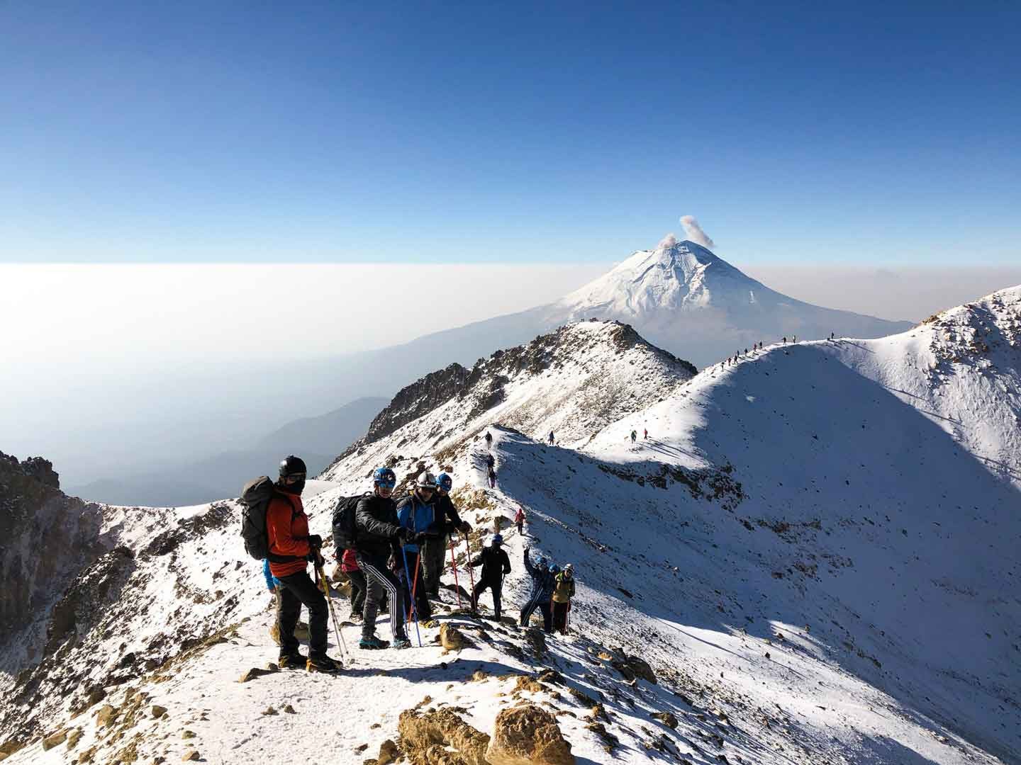
Iztaccíhuatl has no crater. Unlike its smoking neighbour Popocatépetl, it is a dormant, deeply eroded massif whose summits were named for a sleeping woman's body — Cabeza, Pecho, Rodillas, Pies — with the Pecho at 5,215 metres the highest point most climbers aim for. That anatomy explains the difficulty better than any grade: you do not climb one slope, you cross a sequence of false summits, each with its own reascent. The iztaccihuatl hike difficulty comes overwhelmingly from altitude rather than technique. Nothing on the standard Arista del Sol route requires ropework in dry conditions, yet the trailhead at La Joya already stands higher than most European peaks, and the air at the Pecho holds roughly half the oxygen of Mexico City. Headache, nausea and heavy legs are common in unacclimatised visitors; a night at the Refugio de los Cien or a prior day at Paso de Cortés, at 3,600 metres, changes the experience substantially. Underfoot, the terrain punishes carelessness. Long stretches of loose volcanic scree slide backwards with each step, the ridgeline is exposed to wind, and glacial remnants near the Ayoloco cirque can turn hard and icy overnight, making crampons and an ice axe sensible in winter. Route-finding above the ridge is not obvious in cloud, and the park sits inside Parque Nacional Izta-Popo Zoquiapan, where CONANP rangers register climbers at the visitor centre. Who should attempt it, then. Hikers who regularly cover long distances with significant vertical gain, who have felt thin air before and know how their body reacts, will find this a demanding but achievable objective. Complete beginners, anyone arriving directly from sea level, and hikers unwilling to move in the dark should treat the full Izta ascent as a goal to build towards rather than a weekend impulse. Many visitors take the honest middle path: walking to the Altzomoni antenna viewpoint or up to the refuge and back, which delivers the volcanic panorama across to Popocatépetl without the summit commitment. Others hire a certified guide from Amecameca, which raises the safety margin considerably on the upper mountain. Whatever the plan, judge the iztaccihuatl hike difficulty against your own recent record at altitude rather than against distance on paper, and confirm current conditions with the park before travelling — snow line, wind and volcanic advisories all shift through the year.
“Iztaccíhuatl is not one climb but a sequence of false summits, each with its own reascent.”
Understanding Iztaccihuatl Hike Difficulty and Timeframes
This plan suits acclimatised hikers with prior high-altitude experience attempting the Arista del Sol route from La Joya to the Pecho summit at 5,215 m, a round trip of roughly 10 to 14 hours. It is a full-day effort covering about 1,300 m of vertical gain on loose volcanic terrain.
La Joya trailhead start
Register at Paso de Cortés, then begin walking from the La Joya parking area at roughly 3,950 m. Expect the first hour to feel deceptively easy on a graded dirt path before the gradient steepens.
Portillo ridge climb
Ascend the exposed Arista del Sol ridgeline toward the Portillo, gaining around 400 m over loose scree and rock steps. Pace matters more than speed here — most turnarounds happen because hikers burn out on this stretch.
Refugio de Chalchoapan checkpoint
Reach the Grupo de los Cien shelter near 4,750 m, a metal hut used as a rest and turnaround marker. Allow 20 minutes to eat and assess how your group is coping with the thinning air.
Las Rodillas traverse
Cross the knee-shaped rock formations and glacial remnants below El Pecho. This is the technical crux: hands are needed on some sections, and progress typically slows to under 200 vertical metres per hour.
El Pecho summit
Stand on the 5,215 m high point after 5 to 6 hours of climbing. Limit summit time to 30 minutes — cloud build-up and lightning risk rise sharply through the early afternoon.
Controlled descent begins
Retrace the ridge toward La Joya, budgeting 4 to 5 hours. Descending scree is where most ankle and knee injuries occur, so tired legs need shorter steps rather than momentum.
Return to trailhead
Arrive back at La Joya with daylight remaining and sign out. Anyone still above the Portillo at this hour should be prepared for a headlamp descent.
Managing Iztaccihuatl Hike Difficulty Through Optimal Timing
Managing Iztaccihuatl hike difficulty starts with arrival timing. Visitors must arrive within the 07:00–10:00 window to mitigate risks from afternoon high-altitude weather shifts and ensure adequate daylight for the ascent.
Weekday mornings
Minimal—
Lower visitor volume allows for a steady, focused pace on the trail.
Weekend mornings
Moderate—
Early arrivals are essential as trails become more populated after 08:00.
Dry Season (Nov–Mar)
HighCold temperatures; clear skies
Stable conditions offer better visibility but require cold-weather preparation.
Verdict: For the most manageable conditions, plan your arrival between 07:00–10:00 on a weekday during the dry season months of November through March.
Essential Gear to Prepare for Iztaccihuatl Hike Difficulty
Iztaccihuatl tops out above 5,200 m, so the gear and conditioning you sort out in the weeks beforehand determine whether the ascent stays manageable.
-
Start cardio and stair training early — Build six to eight weeks of sustained climbing endurance before attempting the route.
-
Schedule acclimatisation nights above 3,000 m — Sleeping high in the days prior reduces the risk of altitude sickness on summit day.
-
Hire a certified guide for glacier sections — Route-finding above La Joya is complex and crevasse terrain demands experience.
-
Assemble a three-layer clothing system — Base, insulating and windproof shell layers handle temperatures that swing below freezing.
-
Load offline maps and a GPS track — Cloud cover regularly erases visual landmarks along the Arista del Sol ridge.
-
Pack crampons, ice axe and helmet — Firm snow and ice persist near the summit for much of the year.
-
Carry three litres of water and salty snacks — Dry air and exertion at altitude accelerate dehydration and energy loss.
-
Register your plan and check conditions — Call +525979783829 or consult https://www.gob.mx/conanp for current access status.
Operating Hours for Assessing Iztaccihuatl Hike Difficulty
The Paso de Cortés visitor center maintains specific operating hours to support climbers preparing for the Iztaccihuatl ascent. Climbers should align their arrival with these times to ensure access.
| Monday | 09:00–18:00 | |
|---|---|---|
| Tuesday | 09:00–18:00 | |
| Wednesday | 09:00–18:00 | |
| Thursday | 09:00–18:00 | |
| Friday | 09:00–18:00 | |
| Saturday | 07:00–18:00 | |
| Sunday | 07:00–16:00 |
Check availability
Frequently Asked Questions About Iztaccihuatl Hike Difficulty
Everything you need to know about iztaccihuatl hike difficulty